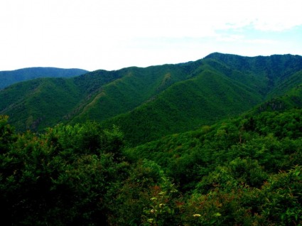
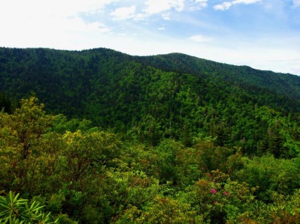
I finally made my way out to the Albright Grove Loop to explore one of the park's sacred stands of old growth forest. Completed the remainder of the Maddron Bald Trail in the process and soared down Snake Den Ridge before the storms hit. 
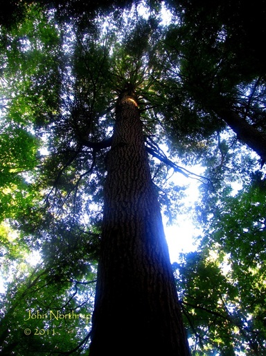
Peering up at one of the first in an overwhelming number of gargantuan Tulip Poplars along the lower reaches of Maddron Bald Trail. 
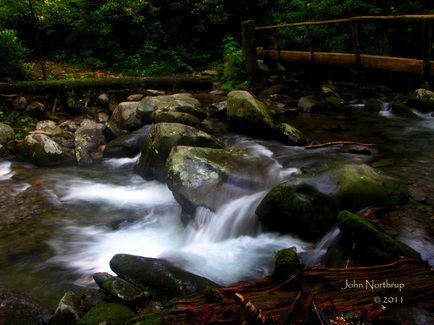
One of the prettier stream crossings, this with a footbridge unlike those later in the hike. 
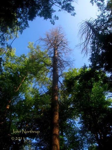
A dead Hemlock still stands tall in Albright Grove. Most of the Hemlocks were dead, more were dying, and only a handful were still alive. A sad reality across the park. 
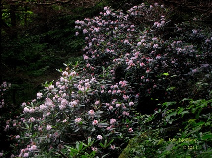
Throughout the mid elevations of the hike, there was Rosebay Rhododendron as far as the eye could see, covering the mountains in white and pink puffs. 
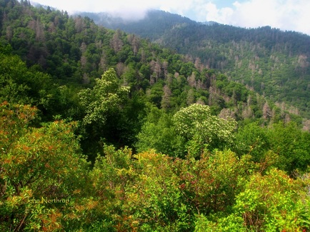
Standing atop an overlook a ways below Maddron Bald, looking out at two Sourwoods in bloom.
0 Comments
I've got to be honest, Low Gap Trail isn't on the list of favorites. And since going anywhere out of Cosby involves a lot of up, it's still the one to take since it's the shortest. This meant I would be taking this route for the third time in a month and a half. Like my last ascent, I wanted to just get it behind me as soon as I could, so I tucked the camera away and focused on my cadence. Along the way, there was still some mountain laurel in bloom, but many more woodland bluets. When I rounded the corner about a mile below Low Gap, I had visions of running into the two yearling bears again. Thankfully, no repeat encounter occurred and I passed without incident. Before I knew it, I had scaled Low Gap. The forest was even greener and fuller than last time, but there was a welcomed surprise. The workers from Trails Days the past weekend had done a great job of clearing the AT of debries and overgrown brush. You could hear my shines give a big sigh of relief with the absence of crud like nettles. Heading west on the AT, I was going in reverse of last week's hike. Even at this elevation, far fewer plants were in bloom. The amazing displays of false solomon's seal were gone, but a good number of catawba rhododendron were still blooming, especially the higher I got. After moving through Camel Gap, I was once again on new terrain. This 2.3 mile section from Camel Gap to Inadu Knob was all I needed to have completed all the AT between Gregory Bald and Lower Mount Cammerer Trails. Usually when you're hiking the AT through the Smokies, you're following the contours of the main crest; thus, higher than the rest of your surroundings. This portion, though, is interesting in that several vistas along the way afford a hiker the chance to look up at a more dominant mountain ridge extending from the main crest. From a vantage point of about 180 degrees, one can see the entire range from the park's second highest summit, Mt. Guyot, out across the long ridge of Balsam Mountain, then Big Cataloochee Mountain, finally ending at Mt. Sterling with the old firetower visible. The clear skies and heath covered slopes ablaze in reds, whites, pinks from all the mountain laurel and rhododendron added to an already impressive sight. Continuing westward, the AT ascends toward Inadu Knob, sometimes along a narrow ridgeline and even rockier trail conditions. At one point I spooked a deer off the trail and out of sight, but the sound of its snorting could be heard through the trees. It's a sound I've heard before when a deer is digusted with something. They exhale air rapidly through their nostrils and the subsequent sound is like screeching car brakes. I took it that my presence there was unwelcome, so I scooted along. I eventually reached Inadu Knob and knocked out another section of the AT. The last time I was here was five years prior on a backpacking trip with my father. We had come from Newfound Gap and descended from this junction down Snake Den Ridge toward Cosby in two days time. To complete today's loop hike, I too would descend Snake Den Ridge yet again. This time I would take a side a trip out to Maddron Bald, now a heath covered ridge, to soak in some views and see what was still blooming. I found that the bald holds a striking similarity to Rainbow Falls' Rocky Spur. Both are well forested at their edges, far enough away as not obscure the views. Sand myrtle, galax, low growing rhododendron, and mountain laurel dominate the immediate vicinity of the overlooks. And with both, one will see the arm of a ridge extending left and upward toward a much higher mountain crest whose slopes form a wall directly in front of you. At the Rocky Spur, one sees the crest of Mt. LeConte on down to Balsam Point of the Bull Head Trail. Here at Maddron Bald, your eyes follow the roller coaster of a ridge left from Inadu Knob, over Old Black, and right across the long Pinnacle Lead. Choosing to press on, I returned to the Snake Den Ridge Trail and dreaded the descent. As I remembered it was steep and rocky the entire way down to Cosby. Well, in those five years since, nothing had changed. About halfway down, though, I ran into several teams of trail maintenance crews for the park clearing out culverts in the trail to help divert water flows. They had covered a lot of territory earlier that day, so the majority of my trek down had me taking long strides and leaps over the numerous ditches. There was only one viewpoint the entire way, a place where the trees had been purposely cut to allow a glimpse of Mt. Cammerer to the west. Looking closely, the windows and triangular top of the firetower were discernible. Before long, I had strolled into the Cosby campground, recently renovated and reopened entirely to public access. After today's hike, I'm another step closer to completing this corner of the park, and now just ten miles away from finishing the Smokies' portion of the AT. |
Thanks for visiting!I appreciate you stopping by. This site is for your enjoyment as much as it is mine. Look for new photos and journal entries about every 1-2 weeks. Archives
November 2011
Categories
All
|